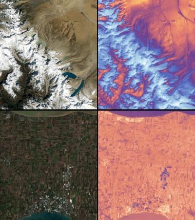
NASA's Landsat 9's first photographs revealed the altering landscapes of the Himalayas in High Mountain Asia and the Northern Australian coastline islands and shorelines.
The joint mission of NASA and the United States Geological Survey (USGS) was meant to help scientists assess critical natural resources and understand the effects of climate change. It collected these images on October 31, which are now available online.
Images show Detroit, Michigan with Lake St. Clair nearby, the convergence of cities and beaches along a shifting Florida coastline, and photos from Navajo Country in Arizona can help us evaluate agricultural health and manage irrigation water.
The stunning images
This is the first chance for Landsat users to properly appreciate the resolution that Landsat 9 gives. "They look great," commented Jeff Masek, Landsat 9 project scientist at Goddard. With Landsat 9 and Landsat 8, we will have a ton of information to observe changes to our earth — every eight days.
NASA's Landsat 9 team is testing and adjusting the satellite's systems and subsystems for a 100-day check-out period before handing it over to USGS in January. The USGS will manage Landsat 9 and Landsat 8, which will capture around 1,500 photos of Earth every day, spanning the world every eight days.
The photographs are quite valuable. Landsat and other satellite data will aid the Navajo Nation track drought conditions and regulating irrigation water. With only 85 rain gauges covering over 27,000 square miles, satellite data and climate models fill in the gaps.

Many people in High Mountain Asia rely on glacier meltwater, and Landsat can watch how those glaciers change with climate change. Some of the changes to the US shoreline are tracked by Landsat and other satellites, including urbanisation and increasing sea levels.
The Great Lakes provide freshwater, leisure, transportation, and habitat for the upper Midwest, and water quality is a major concern. Landsat 9 sees green algae swirls in the summer, which can be dangerous. Landsat 9 will assist scientists and resource managers in spot blooms early and pinpointing regions for additional research.

Landsat 9
Landsat 9 is a collaboration between NASA and the United States Geological Survey (USGS) that will maintain the Landsat program's vital function of repetitive global observations for monitoring, analysing, and controlling Earth's natural resources.
It was launched from Space Launch Complex 3E at Vandenberg Air Force Base, California, on September 27, 2021, using a United Launch Alliance Atlas V 401 launch vehicle.
Landsat is the only U.S. satellite system intended to study changes in the worldwide land surface over time. In addition to designing and building the Landsat 9 spacecraft, Northrop Grumman also integrated and tested two government-supplied sensors. Northrop Grumman will provide mission operations and satellite checkout after launch.
A redesign of Landsat 8, which was deployed in 2013 and is still in orbit, Landsat 9 has significant advantages over its predecessor. As a result, the new satellite can identify minor variations over darker environments like water or deep forest. It can identify over 16,000 colours of colour wavelengths, while its predecessor, Landsat 7, can only detect 256 shades of colour wavelengths. Landsat users will be able to detect small changes never previously possible.
Landsat 9 is equipped with two imaging instruments: the Operational Land Imager 2 (OLI-2), which detects visible, near-infrared, and shortwave infrared light at nine different wavelengths, and the Thermal Infrared Sensor 2 (TIRS-2), which detects thermal radiation at two different wavelengths to monitor the Earth's surface temperatures and their variations.