Pictures and video of a phenomenal cloud pattern formed by 'supercell thunderstorm' on Sunday near Clareton, Wyoming, have wowed weather watchers and netizens alike.
A photo taken by the Basehunters Storm chasers group claims to be "committed to capturing the most unique and close-up tornado footage on the market," as written on their Facebook page, has been making the round on social media throughout Monday and Tuesday.
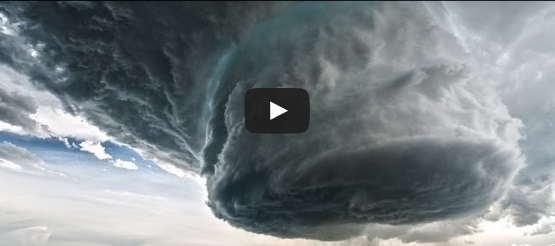
The photo shows the rotating updraft of a supercell thunderstorm over eastern Wyoming, the USA Today notes.
The supercell is one of the classifications of thunderstorm that is characterized by a deep, persistently rotating updraft (vertical movement of air). Among the classification of thunderstorms, the 'supercell' is supposed to be least common and is said to have the potential to be most dangerous.
A video featuring the same spectacular cloud formation, posted by Basehunters on Sunday, has inched over 2.4 million views on YouTube.
Watch the video below:
Here are the pictures doing rounds on Twitter on the same phenomenal natural occurrence:
Supercell over Wyoming landscape yesterday from twitter users @Basehunters pic.twitter.com/zLYDxWZBIa
— Earth Porn (@EpicEarthPorn) May 20, 2014
wow. great job, @Basehunters "Some epic structure by Clareton, WY several hours ago!!! #wywx #weather pic.twitter.com/KOlukHH254 " — Warren Taylor (@rwarrentaylor) May 20, 2014
Some more amazing structure by Gurley, NE today! #NEwx #weather pic.twitter.com/Sei6GvQGe0
— Weather Adventures (@WeatherTours) May 20, 2014