
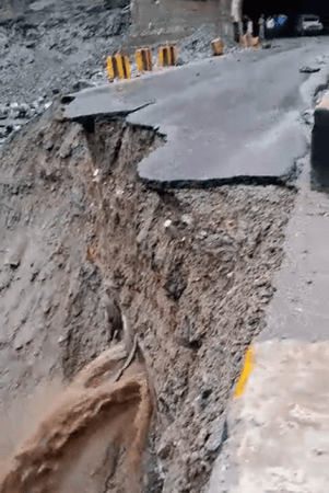
In a major breakthrough for disaster management, the Geological Survey of India (GSI) has successfully completed landslide susceptibility mapping for all landslide-prone mountainous regions across the country, covering approximately 4.3 lakh square kilometers under the National Landslide Susceptibility Mapping (NLSM) programme.
In a written reply to the question of Advocate Adoor Prakash, Union Minister for Science and Technology Dr. Jitendra Singh told the Lok Sabha that the comprehensive mapping exercise, conducted on a 1:50,000 scale, encompasses the entire Himalayan region, the Tertiary Belt of North-eastern India, and the Western Ghats, spanning across 19 states and Union Territories.
"The detailed susceptibility maps categorize areas into high, moderate, and low-risk zones based on their likelihood of landslide occurrence, providing crucial geo-information for regional land-use planning in fragile slope areas," said the minister.

Extensive database of historical landslides
Sharing further details, the Minister said that the GSI has compiled an extensive database of 91,000 historical landslides using both remote sensing technology and field-based data collection.
"Of these, 33,904 landslides have been field-validated, with the database being continuously updated through ongoing post-disaster studies conducted annually," he said.
"The landslide susceptibility maps and inventory are freely available to all stakeholders through GSI's National Geoscience Data Repository (NGDR) and Bhukosh map portal," Dr. Singh stated. The information is also accessible through GSI's Bhusanket portal and the Bhooskhalan mobile application.

High-resolution mapping initiative
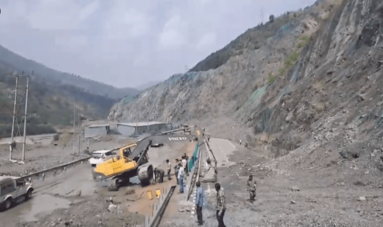
Building upon the NLSM foundation, GSI has advanced to meso-scale mapping at 1:10,000 and 1:5,000 scales. The ambitious project aims to complete the mapping of 200 critical sectors identified through NLSM and state government consultations by 2028. As of the 2024-25 field season, GSI has completed high-resolution mapping for 160 critical sectors and localities.
These detailed maps are designed to support infrastructure development planning in vulnerable hill regions and assist in implementing zoning regulations to ensure community safety.
Site-specific investigations and remedial measures
The Minister further said that over the past five years (2019-2024), GSI has conducted 45 detailed site-specific investigations of chronic landslides across the country on scales of 1:1000 to 1:2000, providing tailored remedial measures for unstable slopes and landslide-affected areas.
"Responding to the increasing frequency of natural disasters, GSI launched the Regional Landslide Forecasting System (RLFS) in 2020, implemented in phases across landslide-prone regions. The sophisticated forecasting system operates on probabilistic rainfall thresholds, Numerical Weather Prediction models, and real-time rainfall data to provide timely warnings for rainfall-induced landslides", the Minister said.
The initiative represents a collaborative effort involving the Indian Meteorological Department (IMD), National Centre for Medium Range Weather Forecasting (NCMRWF), ISRO's National Remote Sensing Centre (NRSC), and various State Disaster Management Authorities for comprehensive data integration and model validation.
Operational landslide early warning system
As part of the multi-consortium LANDSLIP project, GSI has developed a prototype regional Landslide Early Warning System (LEWS) for India. Since the 2025 monsoon season, the system has been providing operational and experimental landslide forecast bulletins for 21 districts across eight states.
Government support for high-risk areas
The Central Government provides specialized assistance to states with high landslide risk through multiple channels. Financial support is available through the National Landslide Risk Mitigation Programme, while the Aapda Mitra scheme, implemented by the National Disaster Management Authority (NDMA), focuses on training community volunteers in disaster response.
The Aapda Mitra scheme, a fully Central government-funded initiative, equips volunteers with essential skills to address immediate community needs in disaster-prone areas, particularly focusing on post-disaster response capabilities.
Related


