
The women wing of Indian National Congress on Friday, December 27, tweeted a map of India that does not include Jammu and Kashmir, and Ladakh. The tweet has since been deleted but received a barrage of reactions.
The post was against the contentious Citizenship Amendment Act (CAA) and read "Stop Yogi Adityanath" with an image of him strangulating the map of India.

Reacting to the image, a Twitter user wrote: "It's insane that the Congress would put out a map of India that doesn't include Kashmir. Did someone from Pakistan make this and send it to you. Congress?"
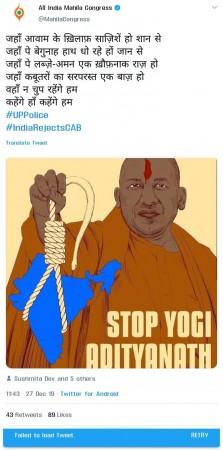
"Congress deletes tweet after showing India without Kashmir. Even a three-year-old knows this is NOT the map of India," wrote another person.
Not an isolated incident
This is not the first time when Congress has shared a 'distorted' map of India, portraying the nation without the northern-most territory.
Congress leader Shashi Tharoor earlier last week had tweeted a map of India sans Kashmir, along with the information of his participation in a rally at Kerala's Kozhikode against CAA.
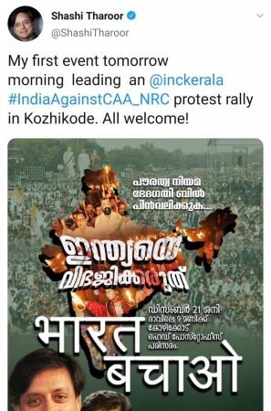
"My first event tomorrow morning leading an @inckerala #IndiaAgainstCAA_NRC protest rally in Kozhikode. All welcome!" tweeted Shashi Tharoor.
"Not the first time, Not last Time. It was Congress who had given POK to Pakistan. They consider it as achievement," a Twitter user had responded to Tharoor.
After being trolled on social media, the Congress leader had deleted his tweet and clarified that he had sought to depict not the territory but the people of India.
"My first event this morning: leading an @inckerala #IndiaAgainstCAA_NRC protest rally in Kozhikode. All welcome! (Replaces an earlier post which sought to depict not the territory but the people of India, in whose name we would be speaking. No wish2feed BJP trolls more fodder.)," he wrote on Twitter.
Earlier in 2017, after the Bharatiya Janata Party-led National Democratic Alliance government completed three years of its first term, the Uttar Pradesh Congress had released a booklet in Lucknow in which Kashmir was labelled as Indian-occupied Kashmir.
The 11th page of the 16-page booklet discussed the China-Pakistan Economic Corridor (CPEC) and carried a map of the project, carrying the label 'India-occupied Kashmir' for the area of Kashmir.


