After its destructive spell over Micronesia, category 5 super typhoon Maysak,which now will be called Chedeng has entered Philippines.
On Sunday, Maysak struck Micronesia's Chuuk State, killing at least five and destroying around 95% of tin houses on the island, according to Guampdn.com.
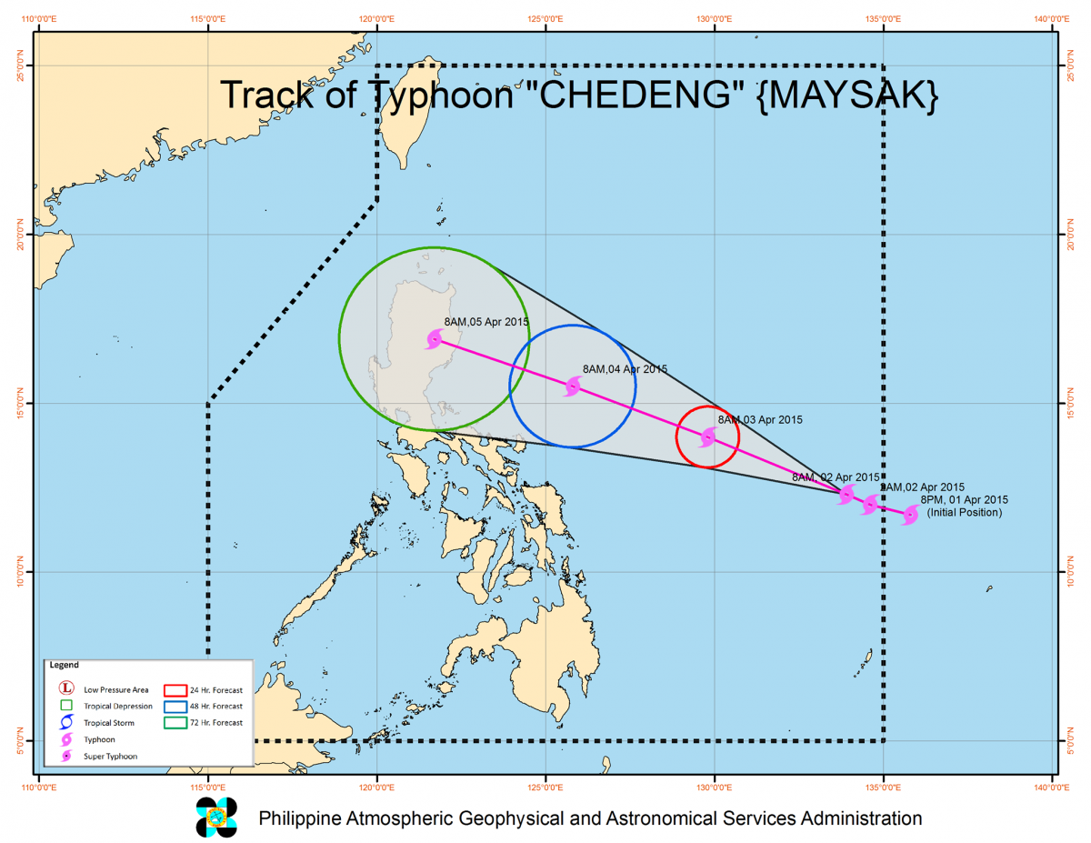
The super typhoon is now moving straight into Philippines and is expected to make landfall in Luzon on Easter Sunday, typhoon tracks plotted by several countries in the Asia-Pacific showed.
The typhoon, which will be called "Chedeng" in the Philippines, entered the Philippine area of responsibility (PAR) on late Wednesday night.
A cyclone is considered a super typhoon when its sustained winds reach at least 220 kph, according to Pagasa.
Super Typhoon Maysak- Live Blog:
Latest
Next 12 hours will be crucial:
- Estimated rainfall amount is from moderate to heavy within the 150 – 200 km radius of the typhoon.
- Within the next 12 hours, PAGASA will raise Public Storm Warning Signal #1 over Bicol and Northern Samar. Hence, sea travel over these areas will be possibly suspended.
- It is estimated to make landfall over eastern coast of Aurora or Isabela by late Saturday (April 4) to early Sunday (April 5)
- The public is alerted against possible flashfloods over low-lying areas and landslides along mountain slopes particularly over Aurora-Isabela area.
- Storm surges and sea surface waves of up to 4 meters are possible over the eastern coast of Samar, Bicol and Aurora-Quezon.
- Fisherfolks are advised not to venture out over the eastern seaboard of Bicol Region and of Visayas.
PAGASA Warning for Manila: Thunderstorm is more likely to develop over National Capital Region within 12 hours.
- Philippines Weather Department Issues Warning against Flash Floods: Philliphines' PAGASA in its official circular stated: Maysak is expected to enter the Philippine Area of Responsibility (PAR) tonight or early morning tomorrow (Thursday) and will be named Chedeng.
- Within the next 24 hours (around Thursday afternoon, April 2), PAGASA will raise Public Storm Warning Signal over Bicol and Samar provinces. Hence, sea travel over these areas will be suspended.
#SUPERTYPHOON #Maysak #Philippines region-wise alert - pic.twitter.com/CR0RTllDGf
— Newsitis (@Newsitis) April 1, 2015
- It is estimated to make landfall over the eastern coast of Aurora, Quezon or Isabela by late Saturday (April 4) or early Sunday (April 5).
- Heavy to at times intense rainfall is expected within the 150-200km radius of the typhoon. The public is alerted against flash-floods over low-lying areas and landslides along mountain slopes particularly over Aurora-Quezon area.Storm surges and sea surface waves of up to 4 meters are possible over the eastern coasts of Samar, Bicol and Aurora-Quezon.
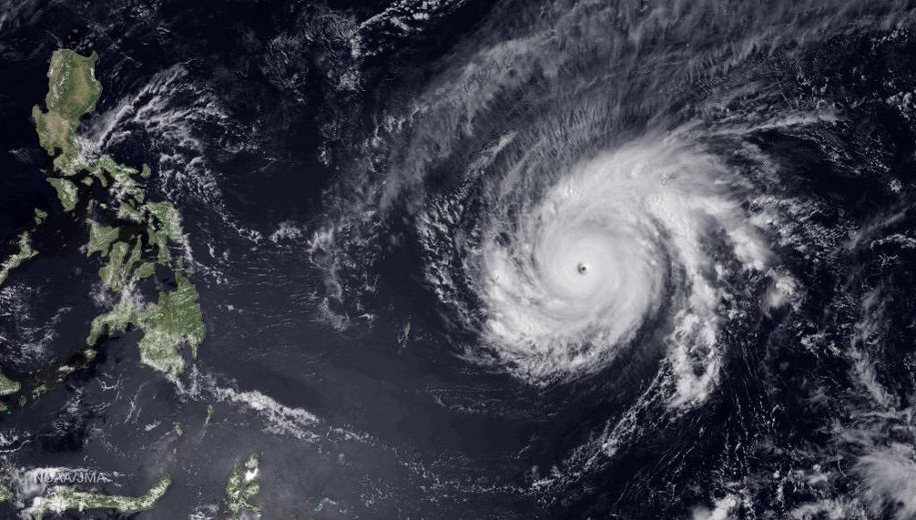
- Images of Maysak captured by NASA from Outer Space [Video]
-
Incredible images of the 'eye' of super-typhoon #Maysak taken by @AstroSamantha on the @Space_Station pic.twitter.com/22nc0Vndj3
— Met Office (@metoffice) April 1, 2015
- What to expect during Holy Week (April 1– 5, 2015)
- Wednesday – Friday (April 1-3): Eastern Luzon will experience good weather today and tomorrow but will have rains and gusty winds starting Friday (April 3).Basically good weather (warm and humid) with the possibility of isolated rainshowers or thunderstorms is expected over the central and western sections of the country until Friday.
- Saturday & Sunday (April 4-5): Rains and gusty winds to stormy weather is expected over Bicol Region, Central-Northern Luzon. Greater Metro Manila area will have rains and gusty winds while the rest of the country will have warm and humid condition.
- Maysak "Extremely Dangerous"
#Maysak over its peak and facing dryer air and cooler water. Still very strong & extremely dangerous #TyphoonMaysak pic.twitter.com/dfFXNwjnPH
— Ronaldo Wilbrink (@WXRonaldo) April 1, 2015
- Philippines warns Residents and Foreign Tourists: As it gears up for making emergency plans for the super typhoon, authorities in the country have issued warning to residents and foreign tourists on its eastern coasts to be ready for Maysak.
- Alexander Pama, executive director of the national disaster agency, said the biggest challenge for authorities would be keeping foreign and Filipino tourists in northern provinces for the weekend safe when Maysak makes landfall.
- With the Easter on Sunday, holidays will begin on Thursday and so thousands of Filipinos will be travelling to the provinces and popular tourist spots. Philippines Chief of Staff, General Gregorio Pio Catapang stated that the storm warning has been raised to 'red alert.' He also added in a press briefing that the country was concerned about the safety of the foreign tourists,especially as if they get caught in the super typhoon, they might not know about evacuation centres or safe zones.
That's one very powerful typhoon! Super Typhoon #Maysak has max sustained winds of 150 mph, with gusts to 185 mph. pic.twitter.com/uzorsFe17g
— Aaron White (@AaronWhiteWDAY) April 1, 2015
- Maysak to damage agricultural crops: The typhoon could damage rice and corn crops in central and northern areas of the Philippines. The damage is likely to be minimal as major harvest of the national staple rice was finished around February.
- Maysak is a rare Typhoon: According to Jeff Masters of Weather Underground, Maysak is "one of only three Category 5 storms ever observed in the Northwestern Pacific prior to April."
- Cabanatuan City will be worst hit by Super Typhoon: Maysak is currently forecast to make landfall near Cabanatuan City, Luzon, Philippines on 5 April as an intense 175 km/h typhoon. The typhoon will continue as a strong tropical storm and then emerge in the south China Sea weakened by the rough terrain.
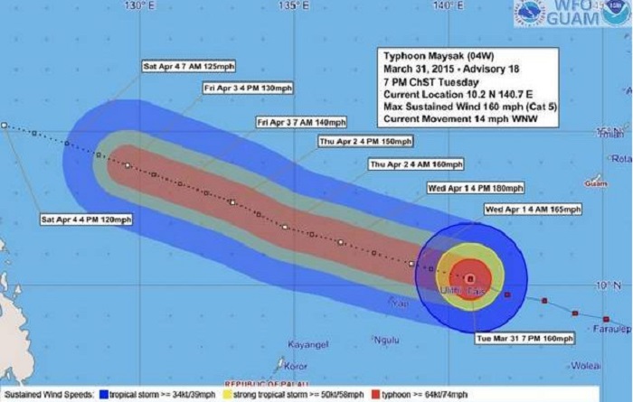
- Typhoon "Maysak" intensified into a Super Typhoon on 31 March and gained a Category 5 hurricane status as per the Saffir-Simpson scale. Maysak is a rare, record breaking Super Typhoon which is expected to peak at 287.1 km/h (178.4 mph) on April 1 or 2, before a weakening trend commences.
- Maysak to enter Philippines Tonight or Tomorrow Morning: According to Philippine Atmospheric, Geophysical and Astronomical Services Administration (PAGASA) This typhoon is still too far to affect any part of the country. It is expected to enter the Philippine Area of Responsibility (PAR) between tonight until tomorrow morning and will be named "CHEDENG". PAGASA will be releasing a the Public Weather Forecast at 5:00PM today while a warning advisory will be issued at 11:00AM tomorrow.
- Philippines Braces for the Super Typhoon: Emergency services and military troops on alert; arranged for food and medical supplies as Typhoon Maysak approaches.
- All Hands on Deck: "As far as the government is concerned, as far as the President is concerned, all hands are on deck, (as) with any expected or unforeseen situations, incidents that may arise during Holy Week," presidential spokesperson Edwin Lacierda said in a Palace briefing.
- Watch Live Updates on Super Typhoon: The National Disaster Risk Reduction and Management Council (NDRRMC) and the Philippine Atmospheric, Geophysical and Astronomical Services Administration (Pagasa) are both expected to provide "timely warnings" on the incoming typhoon.
- Chedeng to make landfall in Luzon: The category 5 super typhoon is now moving straight to the Philippines, is expected to make landfall in Luzon on Easter Sunday.
- The US Navy's Joint Typhoon Warning Center said Wednesday that the intensity of Maysak/Chedeng will weaken while it makes landfall on the Philippine island of Luzon on Sunday with wind speeds of around 160 kilometers per hour.


