
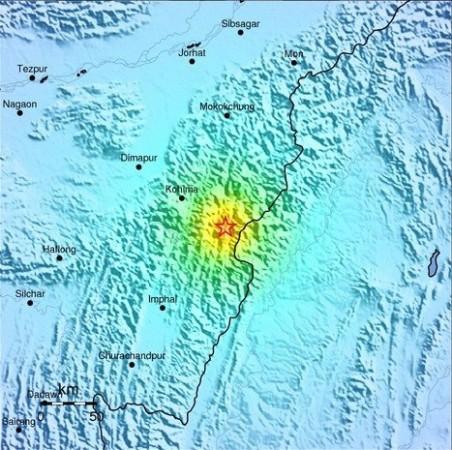
A moderate earthquake measuring 5.6 on the Richter scale jolted Nagaland and India-Myanmar border region in the wee hours on Sunday.
The tremor struck at 01:25:12 AM on Sunday according to United States Geological Survey (USGS). The epicenter was located about 45 kilometres (28 miles) southeast of Kohima, the capital of Nagaland.
The USGS reported that the tremor hit districts Phek, Kohima, Zunheboto and Wokha districts.
There are no reports of casualties and damages so far. However, the tremor, which lasted for a few seconds, woke up the people from their sleep and caused panic.
"I was watching a disaster movie when the quake hit.. rocked me out of my chair.." said Julian Jasokie sheesh on The Naga Blog facebook group.
"I dont think it's a mild tremor this time. It was a dizzying jolt! Hope everyone is safe and sound," added Movi Sapunyi.
"Very low seismic activity may occur for the next 48 hours according to www.world-earthquakes.com. But it's VERY LOW SEISMIC ACTIVITY so we may not even feel it on the ground level..no reason to panic," wrote Menuolhoulie Kire on the blog.
Northeastern states of India are prone to earthquakes. A powerful tremor of 6.9-magnitude hit India's northeastern state of Sikkim and Nepal on September 18, 2011, killing more than 100 people and destroying several houses.
Another moderate earthquake measuring 5.8 on the Richter scale hit Nagaland on July 1, 2012 with its epicenter in Phek district.
The seismic zoning map of India has placed the North-East region in the "Very High Damage Risk Zone". Other places that fall in this zone include Kashmir, Punjab, the Rann of Kutch and the western and central Himalayas.
According to USGS, seismicity in the Himalaya dominantly results from the continental collision of the India and Eurasia plates, which are converging at a relative rate of 40-50 mm/yr. Northward underthrusting of India beneath Eurasia generates numerous earthquakes and consequently makes this area one of the most seismically hazardous regions on Earth. The surface expression of the plate boundary is marked by the foothills of the north-south trending Sulaiman Range in the west, the Indo-Burmese Arc in the east and the east-west trending Himalaya Front in the north of India.


