It seems that none of the manifestations of the earth can escape from Google's eagle eye.
The internet giant, which has been exploring the new streets around the world for its web mapping service, is presently working to include routes to the remote northern villages located in Canada's Arctic region in its map service.
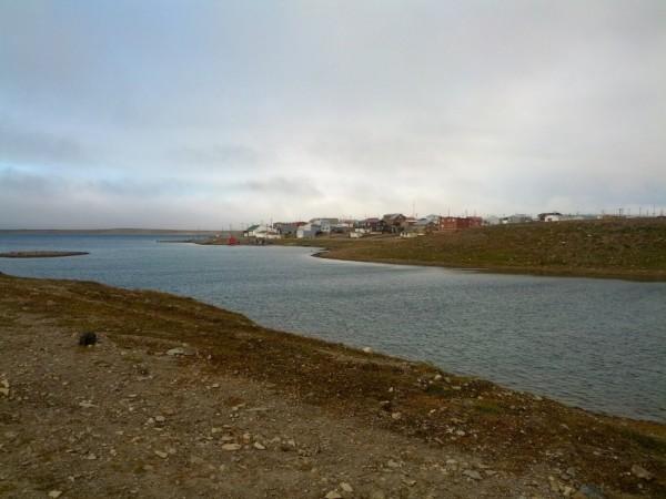
Google on Thursday announced its latest project to map the ancient Arctic regions via its official blog post. "Search for cambridge bay on Google maps and you'll fly to a tiny hamlet located deep in the Kitikmeot Region of Nunavut in Canada's Arctic, surrounded by an intricate lacework of tundra, waterways and breaking ice. High above the Arctic circle, it's a place reachable only by plane or boat," read the official blog post of the search engine giant.
Google said that the isolated village of 1,500 people appears as only a handful of streets, with names like Omingmak ("musk ox") Street and Tigiganiak ("fox") Road.
"There are 4,000 years' worth of stories waiting to be told on this map. Today, we're setting out on an ambitious mission to tell some of those stories and to build the most comprehensive map of the region to date. It is the furthest north the Google Maps Street View team has traveled in Canada, and our first visit to Nunavut. Using the tools of 21st century cartography, we're empowering a community and putting Cambridge Bay on the proverbial map of tomorrow," said the search engine gaint.
To add more authenticity and keep the top crust culture and aesthetics of the villages intact in its web-based map service, the internet major has been working along with the community and local residents by hosting the community 'Map Up' event in Cambridge Bay.
Village elders, local mapping experts and teenagers from the nearby high school gathered a dozen Chromebooks and used Map Maker to add new roads, rivers and lakes to the Google Map of Cambridge Bay and Canada's North, at the event hosted by the search engine.
The volunteers are said to have added hospital, day care, a nine-hole golf course, a territorial park and the remnants of an ancient Dorset stone longhouse which dated to Inuit culture. They have been using both English and Inuktitut one of Nunavut's official languages for building Google's map.
Google said that it's currently surfing the Street View trike around the gravel roads of the hamlet and using a tripod, the same used to capture business interiors, to collect imagery of these amazing places.
The search engine officials also said that they would train the participants of the community to use some of this equipment so they can travel to other communities in Nunavut, and that they would build the most comprehensive and accurate map of Canada's Arctic.
Google said that Candada's Artic region is one of the most isolated places on the face of the planet which will soon be included in the Google maps.